
Introduction
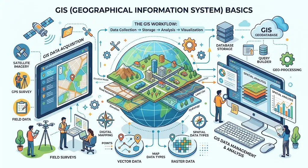
The GIS Basics Course helps you understand how geographic data is used in modern systems. Moreover, it focuses on mapping and spatial analysis.
Additionally, GIS is widely used in planning and research. Therefore, it is important for geography and data-related fields.
Course Overview
First, you will learn geographic data basics. Then, you will understand GIS systems.
Moreover, you will study mapping techniques. Additionally, you will explore spatial analysis tools.
Therefore, you will understand how GIS systems work.
What You Will Learn
First, you learn GIS fundamentals. Then, you learn mapping techniques.
Moreover, you study spatial data analysis. Additionally, you learn GIS software basics.
Therefore, you gain practical geospatial skills.
Skills You Will Gain
- GIS fundamentals
- Spatial data analysis
- Digital mapping skills
- Geospatial data handling
- Cartography basics
- GIS software knowledge
- Location intelligence
Moreover, these skills are useful in many industries.
Benefits of the Course
This course helps you understand how maps and spatial data work. Moreover, it improves your analytical thinking.
Additionally, you learn real-world GIS applications. Therefore, you become ready for geospatial careers.
Who Should Enroll
- Students
- Geography learners
- Data enthusiasts
- IT beginners
- Environmental researchers
Moreover, no advanced experience is required. Therefore, beginners can start easily.
Career Opportunities
- GIS Analyst
- Geospatial Data Analyst
- Mapping Technician
- Remote Sensing Assistant
- Urban Planning Assistant
Moreover, GIS careers are growing in many industries.
Certification
You receive a certificate after completion. Moreover, it validates your GIS skills.
Why Choose This Course
This course is simple and practical. Moreover, it focuses on real-world mapping systems.
Therefore, it is a strong foundation for geospatial careers.
FAQ SECTION
1. What is GIS Basics Course?
It teaches how geographic data and mapping systems work.
2. Is this course beginner friendly?
Yes, it starts from basics.
3. What will I learn?
You will learn mapping and spatial analysis.
4. Do I need coding experience?
No, it is not required.
5. Is this course online?
Yes, it is fully online.
6. Will I get a certificate?
Yes, after completion.
7. What skills will I gain?
You will gain GIS and mapping skills.
8. Can I get a job after this?
Yes, it supports GIS roles.
9. Where is GIS used?
In urban planning, environment, and logistics.
10. Why is GIS important?
It helps analyze location-based data for better decisions.



Reviews
There are no reviews yet.