
INTRODUCTION
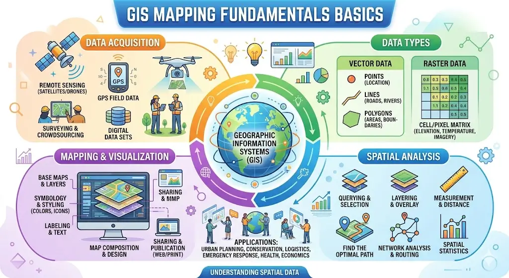
The GIS Mapping Fundamentals Basics Course is a structured beginner-level geospatial training program designed to help learners understand how Geographic Information Systems (GIS) work and how digital mapping is used in real-world industries. GIS is a technology that helps capture, manage, analyze, and visualize geographic and spatial data.
This course focuses on building foundational GIS skills for beginners.
WHAT IS GIS?
GIS (Geographic Information System) is a system used to analyze spatial and geographic data.
Additionally, it helps in mapping and decision-making processes.
It is widely used in planning, engineering, and environmental studies.
COURSE OVERVIEW
This course provides a step-by-step understanding of GIS concepts.
Learners will explore mapping tools and spatial data structures.
Moreover, the course explains real-world GIS applications.
As a result, learners gain practical geospatial skills.
IMPORTANCE OF GIS MAPPING
GIS is important for solving real-world location-based problems.
Moreover, it helps in better planning and resource management.
Consequently, it is used in many industries worldwide.
This course helps learners understand its value and applications.
SPATIAL DATA TYPES
Spatial data represents geographic information.
This section explains vector and raster data formats.
Additionally, it improves understanding of map structures.
COORDINATE SYSTEMS
Coordinate systems help locate positions on Earth.
This section explains latitude, longitude, and projections.
Moreover, it ensures accurate mapping results.
MAP CREATION AND VISUALIZATION
Map creation is a core GIS skill.
This section explains how to design and visualize maps.
Additionally, it improves data interpretation skills.
GIS DATA ANALYSIS
GIS helps analyze geographic patterns.
This section explains spatial analysis techniques.
Moreover, it supports decision-making processes.
REAL-LIFE APPLICATIONS
GIS is used in many industries and sectors.
This section explains applications in urban planning, agriculture, disaster management, and transportation.
Moreover, it improves efficiency and planning.
SKILLS YOU WILL GAIN
After completing this course, learners will develop:
GIS mapping skills
Spatial data analysis
Map creation techniques
Coordinate system understanding
Data visualization skills
Geospatial technology knowledge
Analytical thinking
Problem-solving skills
Technical mapping skills
Industry application skills
BENEFITS OF THE COURSE
The GIS Mapping Fundamentals Basics Course helps learners build strong geospatial skills. Additionally, it improves analytical and technical abilities.
Furthermore, GIS skills are in high demand across industries.
Benefits include:
Better career opportunities
Strong technical knowledge
High-demand digital skills
Improved data analysis ability
Urban planning knowledge
Environmental analysis skills
Research capabilities
Career growth in GIS field
WHO SHOULD ENROLL
This course is suitable for:
Students
Urban planning learners
Engineers
Researchers
Geography students
Environmental scientists
Agriculture analysts
Government job aspirants
IT professionals (beginners)
Anyone interested in mapping technologies
CAREER OPPORTUNITIES
After completing this course, learners may pursue roles such as:
GIS Analyst (Entry Level)
Mapping Technician
Urban Planning Assistant
Survey Assistant
Geospatial Data Operator
Cartography Assistant
Environmental Data Assistant
Remote Sensing Support Staff
Infrastructure Planning Assistant
GIS Technician Trainee
CERTIFICATION DETAILS
Upon successful completion of the GIS Mapping Fundamentals Basics Course, learners receive a certification recognizing their skills in GIS mapping, spatial data analysis, and geospatial technologies.
CONCLUSION
The GIS Mapping Fundamentals Basics Course provides a strong foundation in digital mapping, spatial analysis, and geographic data systems. It helps learners build practical geospatial skills for multiple industries.
Therefore, mastering GIS opens valuable opportunities in urban planning, environmental science, infrastructure development, and modern technology fields.
FAQ SECTION
1. What is GIS Mapping Fundamentals Basics Course?
It is a beginner-level course that teaches GIS and digital mapping.
2. Who should take this course?
This course is suitable for students, engineers, and researchers.
3. Do I need experience?
No, it is beginner-friendly.
4. What will I learn in this course?
You will learn GIS tools, mapping, and spatial analysis.
5. Is this useful for jobs?
Yes, GIS skills are in high demand.
6. Will I learn map creation?
Yes, digital mapping is included.
7. Is spatial analysis included?
Yes, basic GIS analysis is covered.
8. Will I get a certificate?
Yes, a completion certificate is provided.
9. Is this useful for government jobs?
Yes, it supports planning and survey roles.
10. Is this useful for career growth?
Yes, it helps in GIS and data-related careers.


Reviews
There are no reviews yet.