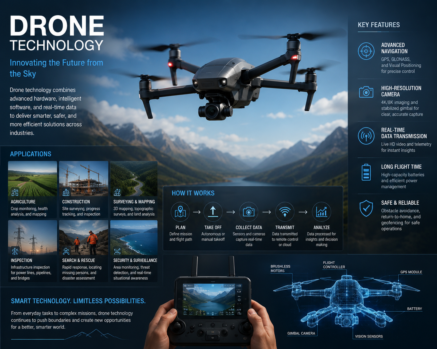
Drone Technology is transforming industries by enabling aerial innovation, automation, and data collection. This comprehensive course introduces learners to the fundamentals of drones, covering hardware components, flight mechanics, navigation systems, and safety protocols.
Students will gain hands-on experience with drone operation, aerial photography, and data analysis, while exploring applications in agriculture, logistics, construction, defense, and environmental monitoring. The course also emphasizes regulatory compliance, ethical use, and emerging trends such as AI-powered drones and autonomous flight systems.
By the end of this course, participants will be able to:
- Understand the basics of drone hardware, sensors, and flight control systems.
- Operate drones safely and efficiently under aviation guidelines.
- Capture aerial imagery and video for professional use.
- Apply drones in industries such as agriculture, surveying, and logistics.
- Analyze drone-collected data for decision-making and innovation.
- Explore advanced topics like autonomous drones, swarm technology, and AI integration.
This course is ideal for students, entrepreneurs, and professionals who want to harness drone technology for business, research, or creative projects. With practical assignments and real-world case studies, you’ll gain the confidence to innovate and lead in the fast-growing drone industry.
FAQ SECTION
What is the Drone Technology Course?
The Drone Technology Course provides foundational knowledge of UAV systems, drone operations, safety procedures, and industry applications.
Who should enroll in this course?
Students, engineers, surveyors, aviation enthusiasts, photographers, entrepreneurs, and professionals interested in drone technology can benefit from this course.
Do I need prior drone experience?
No. The course is designed for beginners and does not require previous drone or aviation knowledge.
What topics are covered in the course?
The course covers drone systems, UAV technology, flight principles, safety practices, regulations, mapping, surveying, and aerial applications.
Is certification included?
Yes. Participants receive a certificate upon successful completion of the course.
Will I learn about drone regulations?
Yes. The course includes an overview of drone regulations, compliance requirements, and responsible UAV operations.
Does the course cover drone mapping and surveying?
Yes. Learners gain an introduction to drone-based mapping, surveying, and geospatial applications.
Can this course help me start a career in the drone industry?
Yes. The course provides foundational knowledge relevant to various drone-related career paths.
What career opportunities are available after completing this course?
Graduates may pursue opportunities in drone operations, surveying, aerial photography, inspection services, GIS support, agriculture technology, and logistics.
Can I study this course online?
Yes. Depending on the provider, online learning options may be available.


Reviews
There are no reviews yet.